Home
States
Colorado
Connecticut
Maine
Massachusetts
New Hampshire
New York
Rhode Island
Utah
Vermont
View All
Lists
NE 4,000 Footers
NE 100 Highest
NH 4,000 Footers
NH 100 Highest
NH 52 With A View
NH Belknap Range
NH Ossipee 10
Links
Trail Conditions
Trip Log
Sunrises
Sunsets
About
|
Little Haystack Mountain, Mt. Lincoln, Mt. Truman, Mt. Lafayette
Franconia, NH, Lincoln, NH
Trailheads, measurements, times, distances, and maps are all approximate and relative to the hike(s) as shown below.

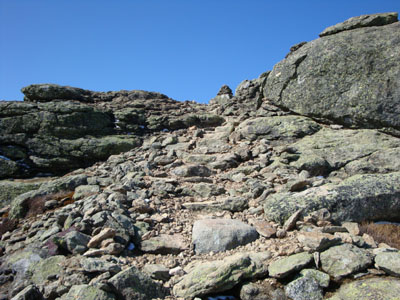
Looking up the Falling Waters Trail
Route: Old Bridle Path, Falling Waters Trail, (Little Haystack Mountain), Franconia Ridge Trail, (Mt. Lincoln), Franconia Ridge Trail, (Mt. Truman), Franconia Ridge Trail, (Mt. Lafayette), Greenleaf Trail, Old Bridle Path
With the first quasi-summer temperatures of the year, I was itching to get outside. Thus, I took off a few hours and headed out for the day a bit early.
The bluebird day and warm temperatures helped get me moving, despite being somewhat tired. The Falling Waters Trail was quite scenic, as the numerous waterfalls were roaring. Of course, the trail was also packed with folks descending at the end of their loops.
Shortly before reaching treeline, I passed the last people I would see all day. Thus, I had the entire alpine zone portion of the hike (as well as the descent) completely to myself - just about impossible on the Franconia Ridge in good weather!
While much of the ridge was bare (except for some drifts from the recent snow), the descent off Mt. Lafayette was brutal - the recent snow was covering up slush and running water, making things very slippery and wet. As a result, the hut was quite a welcome sight.
The Old Bridle Path wasn't much better, until I finally dropped below the new-snow line. After that, things were increasingly easier, eventually transitioning to dry, bare ground.
Other than the nasty hodgepodge of spring conditions, it was a beautiful afternoon/evening for a hike!
| Hike Ratings |
|
Getting To Trailhead: |
Easy |
| Destination: |
Little Haystack Mountain |
|
Length: |
Moderate |
|
Steepness: |
Difficult |
|
Navigation: |
Easy |
|
Views: |
Excellent |
|
Crowds: |
Heavy |
| Destination: |
Mt. Lincoln |
|
Length: |
Moderate |
|
Steepness: |
Difficult |
|
Navigation: |
Easy |
|
Views: |
Excellent |
|
Crowds: |
Minimal |
| Destination: |
Mt. Truman |
|
Length: |
Difficult |
|
Steepness: |
Moderate |
|
Navigation: |
Moderate |
|
Views: |
Excellent |
|
Crowds: |
Minimal |
| Destination: |
Mt. Lafayette |
|
Length: |
Difficult |
|
Steepness: |
Moderate |
|
Navigation: |
Moderate |
|
Views: |
Excellent |
|
Crowds: |
Minimal |
|
| Hike Stats |
|
Date Hiked: |
Friday, April 24, 2009 |
| Hike Commenced: |
1:51 PM |
| Parking Elevation: |
1,770' |
| Destination: |
Little Haystack Mountain |
| Ascent Commenced: |
1:52 PM |
| Summit Reached: |
3:48 PM |
| Time Elapsed: |
01:56 |
| Trailhead Elevation: |
1,785' |
| Summit Elevation: |
4,780' |
| Vertical Gain: |
3,195' |
| Destination: |
Mt. Lincoln |
| Ascent Commenced: |
3:48 PM |
| Summit Reached: |
4:14 PM |
| Time Elapsed: |
00:26 |
| Trailhead Elevation: |
4,780' |
| Summit Elevation: |
5,089' |
| Vertical Gain: |
469' |
| Destination: |
Mt. Truman |
| Ascent Commenced: |
4:17 PM |
| Summit Reached: |
4:31 PM |
| Time Elapsed: |
00:14 |
| Trailhead Elevation: |
5,089' |
| Summit Elevation: |
5,000' |
| Vertical Gain: |
130' |
| Destination: |
Mt. Lafayette |
| Ascent Commenced: |
4:33 PM |
| Summit Reached: |
4:54 PM |
| Time Elapsed: |
00:21 |
| Trailhead Elevation: |
5,000' |
| Summit Elevation: |
5,260' |
| Vertical Gain: |
380' |
|
|
| Hike Ended: |
7:32 PM |
| Hike Time Elapsed: |
05:41 |
| Hike Distance: |
9 miles |
| Hike Vertical Gain: |
4,354' |
|

Old Bridle Path trailhead

Looking south from near the summit of Little Haystack Mountain

The Franconia Ridge Trail on the way to Mt. Lincoln

Looking over the Twins and Bonds at the Presidentials from Mt. Lincoln

The Franconia Ridge Trail on the way to Mt. Truman

Mt. Garfield as seen from Mt. Truman

Looking the Franconia Ridge Trail between Mt. Truman and Mt. Lafayette

Looking southeast from Mt. Lafayette


Directions to trailhead: Take Interstate 93 north from Lincoln to the Lafayette Place exit.
Back to Little Haystack Mountain Profile
Back to Mt. Lincoln Profile
Back to Mt. Truman Profile
Back to Mt. Lafayette Profile
|