Home
States
Colorado
Connecticut
Maine
Massachusetts
New Hampshire
New York
Rhode Island
Utah
Vermont
View All
Lists
NE 4,000 Footers
NE 100 Highest
NH 4,000 Footers
NH 100 Highest
NH 52 With A View
NH Belknap Range
NH Ossipee 10
Links
Trail Conditions
Trip Log
Sunrises
Sunsets
About
|
Teneriffe Mountain
Milton, NH
Trailheads, measurements, times, distances, and maps are all approximate and relative to the hike(s) as shown below.

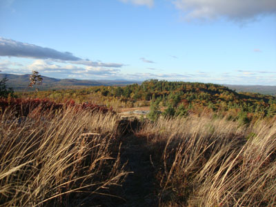
Looking down the trail to Teneriffe Mountain
After hiking in the Moose Mountains, I decided to do a quick walk up to the summit of Teneriffe Mountain.
Starting on Teneriffe Road, I headed up a driveway. Shortly after passing a small building on the left, I took a left onto a herd path, which led its way up the hill through a private blueberry farm. Continuing over a ledgy crag, I followed the path to another height of land, where I found the benchmark. From the benchmark area, there were excellent views to the south and east, while from the ledgy crag, there were great views to the north.
| Hike Ratings |
|
Getting To Trailhead: |
Easy |
| Destination: |
Teneriffe Mountain |
|
Length: |
Easy |
|
Steepness: |
Easy |
|
Navigation: |
Easy |
|
Views: |
Excellent |
|
Crowds: |
Minimal |
|
| Hike Stats |
|
Date Hiked: |
Saturday, October 16, 2010 |
| Hike Commenced: |
4:53 PM |
| Parking Elevation: |
967' |
| Destination: |
Teneriffe Mountain |
| Ascent Commenced: |
4:53 PM |
| Summit Reached: |
4:59 PM |
| Time Elapsed: |
00:06 |
| Trailhead Elevation: |
967' |
| Summit Elevation: |
1,090' |
| Vertical Gain: |
128' |
|
|
| Hike Ended: |
5:09 PM |
| Hike Time Elapsed: |
00:16 |
| Hike Vertical Gain: |
133' |
|

Teneriffe Mountain Trail trailhead off

Looking at the Moose Mountains from near the summit of Teneriffe Mountain


Directions to trailhead: From Route 125 in Milton, take Teneriffe Road under Route 16 and up to the col of Teneriffe Mountain. At the height of land on the road, there is a ledgy area on the right where one can park. Across the street, proceed on foot up the driveway.
Back to Teneriffe Mountain Profile
|