Mt. Hale Trail
State: NH |
The Mt. Hale Trail, also known as the Firewarden's Trail, was built to assemble and service the former Mt. Hale fire tower.
|
|
| Mt. Hale Trail Details |
|
| Also Known As: |
Firewardens Trail |
|
| Location: |
White Mountains - Pemigewasset |
|
| Peak: |
Mt. Hale |
|
| Opened: |
1928 |
|
| Closed: |
1950s |
|
| Reason Closed: |
|
|
| Guidebook Descriptions: |
|
1931 AMC White Mountain Guide
Mt. Hale Trail. (W.M.N.F.)
Take the road (the former route to North Twin) which leaves the S. side of the Daniel Webster Highway ½ m. W. of the B. & M. R.R. Station at Twin Mountain and leads up the Little River Valley. It is passable for autos about 1 ½ m. to the first crossing of the river. About 1/8 m. beyond the third crossing (all bridges down) the path, built in 1928 for a tractor to haul material for the tower, diverges to the L. from the main logging road and at once crosses the river a fourth time. It runs N. a short distance, soon swinging R. and ascending by easy grades and numerous zigzags. A large part of the ridge has been burned over but the young growth of birch and cherry shades the path. Near the summit the trail passes about ½ m. through a patch of old spruce. In a slight col just before reaching the summit, water may be obtained in the ranger’s spring on a side trail to the L. (E.).
Distances. Daniel Webster Highway to first crossing of Little River 1.4 m. (35 min); to forth crossing 3 ½ m. (1 hr. 30 min.); to summit 5 ½ m. (3 hr. 30 min.).
1934 AMC White Mountain Guide
Mt. Hale Trail. (W.M.N.F.)
Take the road (the former route to North Twin) which leaves the S. side of the Daniel Webster Highway ½ m. W. of the B. & M. R.R. Station at Twin Mountain and leads up the Little River Valley. It is passable for autos about 1 ½ m. to the first crossing of the river. About 1/8 m. beyond the third crossing (all bridges down) the path, built in 1928 for a tractor to haul material for the tower, diverges to the L. from the main logging road and at once crosses the river a fourth time. It runs N. a short distance, soon swinging R. and ascending by easy grades and numerous zigzags. A large part of the ridge has been burned over but the young growth of birch and cherry shades the path. Near the summit the trail passes about ½ m. through a patch of old spruce. In a slight col just before reaching the summit, water may be obtained in the ranger’s spring on a side trail to the L. (E.).
Distances. Daniel Webster Highway to first crossing of Little River 1.4 m. (35 min); to forth crossing 3 ½ m. (1 hr. 30 min.); to summit 5 ½ m. (3 hr. 30 min.).
1940 AMC White Mountain Guide
Mt. Hale Trail (WMNF)
Take the road which leaves the S side of the Daniel Webster Highway ½ m. W of the B. & M. RR Station at Twin Mountain and leads up the Little River Valley. It is passable for autos about 1 ½ m. to the first crossing of the river. About 1/8 m. beyond the third crossing (all bridges down) the path diverges L from the main logging road and at once crosses the river a fourth time. It runs N a short distance, soon swinging R and ascending by easy grades and numerous zigzags. Near the summit the trail passes about ½ m. through a patch of old spruce. In a slight col just before reaching the summit, water may be obtained in the ranger’s spring on a side trail to the L (E).
Distances. D.W. Highway to: first crossing of Little River 1.4 m. (35 min.); fourth crossing 3 ½ m. (1 hr. 30 min.); summit 5 ½ m. (3 hrs. 30 min.).
From the fourth river crossing to the summit, this trail affords, with 10 to 12 in. of snow, an excellent ski run for intermediate skiers. In this 2 m. the trail, 6 to 10 ft. wide, drops about 2,000 ft.
1948 AMC White Mountain Guide
Mt. Hale Trail (WMNF)
This trail leads L from the Little River Trail (supra) 2 ½ m. from the Daniel Webster Highway (US 3). It immediately crosses the river a fourth time. It runs N a short distance, soon swinging R and ascending by easy grades and numerous zigzags. Near the summit the trail passes about ½ m. through a patch of old spruce. About ½ below the summit the Tuttle Brook Trail enters L, and in a slight col 0.2 m. below the summit, water may be obtained in the ranger’s spring on a side trail to the L (E).
Distance. Little River Trail to Mt. Hale 2.5 m. (2 hrs.).
|
|
| Images: |
|
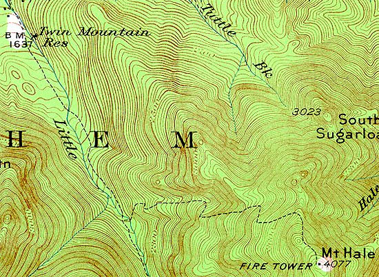
1929 USGS map of Mt. Hale

1934 AMC map of Mt. Hale
|
|
| Links: |
|
|
|
| Last updated 2011-08-19 |
| Disclaimer: Data provided for academic and historical purposes only. Respect all signs. |
|
|