Home
States
Colorado
Connecticut
Maine
Massachusetts
New Hampshire
New York
Rhode Island
Utah
Vermont
View All
Lists
NE 4,000 Footers
NE 100 Highest
NH 4,000 Footers
NH 100 Highest
NH 52 With A View
NH Belknap Range
NH Ossipee 10
Links
Trail Conditions
Trip Log
Sunrises
Sunsets
About
|
Mt. Greylock
Adams, MA
Trailheads, measurements, times, distances, and maps are all approximate and relative to the hike(s) as shown below.

Looking up the Thunderbolt Trail
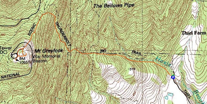
Route: Thunderbolt Trail
Since I was in the area, I decided I'd do a quick but strenuous hike up Mt. Greylock. Arriving at the makeshift parking area at the bottom of the Thunderbolt Trail, I quickly set foot up the trail, using the foot trail instead of the ski trail at one point. The foliage colors along the trail down low were quite nice.
While it is certainly a challenging trail, I recall it being relatively steeper in my previous ascent a few years earlier. Nonetheless, it's still quite a workout.
Reaching the summit, I was surprised to see the parking lots and roads all paved and painted - I wonder why they weren't able to open the auto road for the fall foliage season?
The views from the summit vistas were excellent (though it would have been much nicer had the tower been open). Since I wanted to get another short hike in, I didn't loiter for too long.
Descending and reaching the bottom of the trail, I could tell things were getting busier as the day progressed - and quite understandably, as the weather and foliage were great!
| Hike Ratings |
|
Getting To Trailhead: |
Easy |
| Destination: |
Mt. Greylock |
|
Length: |
Moderate |
|
Steepness: |
Difficult |
|
Navigation: |
Easy |
|
Views: |
Excellent |
|
Crowds: |
Moderate |
|
| Hike Stats |
|
Date Hiked: |
Saturday, October 18, 2008 |
| Hike Commenced: |
9:49 AM |
| Parking Elevation: |
1,215' |
| Destination: |
Mt. Greylock |
| Ascent Commenced: |
9:49 AM |
| Summit Reached: |
10:48 AM |
| Time Elapsed: |
00:59 |
| Trailhead Elevation: |
1,215' |
| Summit Elevation: |
3,491' |
| Vertical Gain: |
2,336' |
|
|
| Hike Ended: |
12:13 PM |
| Hike Time Elapsed: |
02:24 |
| Hike Vertical Gain: |
2,426' |
|

The Thunderbolt Trail trailhead

Looking at Mt. Monadnock from near the Mt. Greylock summit


Directions to trailhead: Take Route 8 south from North Adams. Take a right onto Friend Street, which eventually becomes West Road. Take a right onto Gould Road, then bear right onto Thiel Road. The Thunderbolt Foot Trail trailhead will be at the end of this road.
Back to Mt. Greylock Profile
|