Home
States
Colorado
Connecticut
Maine
Massachusetts
New Hampshire
New York
Rhode Island
Utah
Vermont
View All
Lists
NE 4,000 Footers
NE 100 Highest
NH 4,000 Footers
NH 100 Highest
NH 52 With A View
NH Belknap Range
NH Ossipee 10
Links
Trail Conditions
Trip Log
Sunrises
Sunsets
About
|
Mt. Chocorua, Bald Mountain
Tamworth, NH, Albany, NH
Trailheads, measurements, times, distances, and maps are all approximate and relative to the hike(s) as shown below.

The Skull Cairn Trail
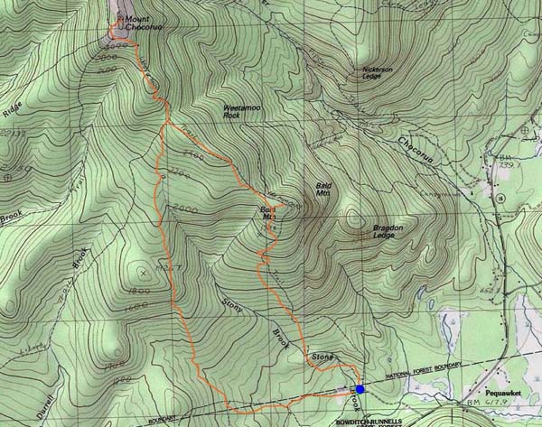
Route: Old Mail Road, Skull Cairn Trail, Hammond Trail, Liberty Trail, (Mt. Chocorua), Liberty Trail, Hammond Trail, bushwhack, (Bald Mountain), bushwhack, Hammond Trail
Old Mail Road was generally dry. Skull Cairn Trail was fairly easy to follow if one has the ability to follow herd paths. Officially abandoned, but judging by prints, clipping, etc., still actively used, presumably by locals. Crevasse scramble was fun. Swamp near the top was mostly dry. Scramble not too far above that was wet, so a little tricky.
Liberty Trail had some wet ledge, but otherwise was dry. Windy conditions on the summit, so only a few dozen people hunkered down.
Hammond Trail was generally dry. Followed a herd path out to the Bald Mountain ledge. Lots of blueberries on Hammond and on Bald.
| Hike Ratings |
|
Getting To Trailhead: |
Easy |
| Destination: |
Mt. Chocorua |
|
Length: |
Moderate |
|
Steepness: |
Very Difficult |
|
Navigation: |
Difficult |
|
Views: |
Excellent |
|
Crowds: |
Heavy |
| Destination: |
Bald Mountain |
|
Length: |
Moderate |
|
Steepness: |
Difficult |
|
Navigation: |
Difficult |
|
Views: |
Excellent |
|
Crowds: |
Moderate |
|
| Hike Stats |
|
Date Hiked: |
August 6, 2017 |
| Parking Elevation: |
600' |
| Destination: |
Mt. Chocorua |
| Time Elapsed: |
03:46 |
| Trailhead Elevation: |
600' |
| Summit Elevation: |
3,474' |
| Vertical Gain: |
2,954' |
| Destination: |
Bald Mountain |
| Time Elapsed: |
01:33 |
| Trailhead Elevation: |
3,474' |
| Summit Elevation: |
2,140' |
| Vertical Gain: |
100' |
|
|
| Hike Time Elapsed: |
06:39 |
| Hike Vertical Gain: |
3,104' |
|

The Bolles Reserve trailhead on Scott Road

The Liberty Trail

Looking the Three Sisters (left) from Mt. Chocorua

The Hammond Trail

Looking at Mt. Chocorua from Bald Mountain


Directions to trailhead: Take Route 16 north from West Ossipee. Shortly after passing Chocorua Lake, take a left onto Scott Road (very small sign, large boulder on the right side of Route 16 at the junction). Head down the dirt road. The Hammond Trail mini parking lot and trailhead will be on the right.
Back to Mt. Chocorua Profile
Back to Bald Mountain Profile
|