Home
States
Colorado
Connecticut
Maine
Massachusetts
New Hampshire
New York
Rhode Island
Utah
Vermont
View All
Lists
NE 4,000 Footers
NE 100 Highest
NH 4,000 Footers
NH 100 Highest
NH 52 With A View
NH Belknap Range
NH Ossipee 10
Links
Trail Conditions
Trip Log
Sunrises
Sunsets
About
|
Mt. Roberts
Moultonborough, NH
Trailheads, measurements, times, distances, and maps are all approximate and relative to the hike(s) as shown below.
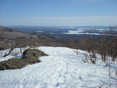
Looking down the Mt. Roberts Trail
Route: Mt. Roberts Trail
After my unsuccessful attempt at hiking Quarry Mountain the day before, I wasn't overly inspired to go hiking. Nonetheless, I decided to do something nearby.
The previous time I hiked Mt. Roberts, I started at the hiker parking lot on Route 171 - way too much of a hike just to get to the trailhead, in my opinion. I had often read about parking at the nearby bottling plant, as if it was an unofficial parking area. Trying it out myself, I was surprised to see a signed hiking parking lot near the plant, alongside the road, only a few minutes from the Mt. Roberts Trail trailhead.
The trail hadn't used in recent days, however it was still for the most part easy to follow - drifting off the center of it, however, meant postholing - even with snowshoes.
The ledge area was nice, just as I had remembered it - the views from here are amongst the best in the Lakes Region.
At the top of the ledges, I somehow lost the trail. There was very little snow my previous time on the trail, so I was able to follow the blazes painted on the ledges. Just before the woodline, the trail does a sharp left turn where it seems as if it's actually going straight into the woods. I bushwacked around a bit, finally finding the trail after poking around for a few minutes.
The views from the summit were strong (though not as good as the ledges) - Mt. Washington was sticking up in the background.
The descent was non-eventful - just great views throughout the ledge area. Seeing that part of the fence was down and that others had done it at some point, I cut cross the pasture at the bottom, replacing a longer woods walk with a nice scenic field walk.
Hopefully spring is on the way!
| Hike Ratings |
|
Getting To Trailhead: |
Easy |
| Destination: |
Mt. Roberts |
|
Length: |
Moderate |
|
Steepness: |
Moderate |
|
Navigation: |
Moderate |
|
Views: |
Excellent |
|
Crowds: |
Minimal |
|
| Hike Stats |
|
Date Hiked: |
Thursday, April 3, 2008 |
| Hike Commenced: |
3:49 PM |
| Parking Elevation: |
1,240' |
| Destination: |
Mt. Roberts |
| Ascent Commenced: |
3:56 PM |
| Summit Reached: |
5:14 PM |
| Time Elapsed: |
01:18 |
| Trailhead Elevation: |
1,250' |
| Summit Elevation: |
2,582' |
| Distance: |
2.5 miles |
| Vertical Gain: |
1,407' |
|
|
| Hike Ended: |
6:33 PM |
| Hike Time Elapsed: |
02:44 |
| Hike Distance: |
5 miles |
| Hike Vertical Gain: |
1,582' |
|

Mt. Roberts Trail trailhead near the horse barn

Looking at the Sandwich Range, from the Sandwich Dome to Mt. Passaconaway, from the Mt. Roberts summit.


Directions to trailhead: Take Route 109 South from Route 25. Bear left onto Route 171. Shortly thereafter, take a left onto Ossipee Park Road. The small hiker parking lot is located just after the gatehouse, on the right. Continue on the road on foot, taking a left at the intersection. The Mt. Roberts Trail trailhead is located at the corner of the field near the barn.
Back to Mt. Roberts Profile
|


